Winkel Tripel Projections
|
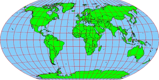
| Figure 1. A Winkel Tripel projection.
|
The Winkel Tripel projection was developed in 1921 by Oswald
Winkel (1873 - 1953). Contrary to popular belief, Tripel is not
somebody's name; it is a German term meaning a combination of three
elements. Winkel choose the name Tripel because he had
developed a compromise projection; it does not eliminate area, direction or
distance distortions; rather, it tries to minimize the sum of all three.
Prior to 1998, the Winkel Tripel projection was not considered particularly
exceptional. However, in 1998 the National Geographic Society announced that it
was adopting the Winkel Tripel as its standard projection for maps of the entire
world. As a result of this announcement, interest in the Winkel Tripel
projection has skyrocketed over the last few years.
The Winkel Tripel is unusual in that it is created by averaging the
X and Y coordinates from two other seldom-used
projections: the Aitoff and the Equirectangular. The result is a projection that
looks a lot like the Robinson
(but remember that Winkel developed his projection about 42 years before
Robinson developed his, so you can't accuse Winkel of plagiarism). However, the
Winkel Tripel has a few unique qualities of its own. For example, lines
of latitude in a Robinson
projection are parallel straight lines, while in a Winkel Tripel they are
slightly curved, nonparallel lines.
- Form:
The Winkel Tripel has a modified planner form, which means that
the developable
surface is slightly curved, and not completely flat as it is in a
projection with a true planner
form.
- Case:
Winkel tripel projections are typically secant,
although it is not uncommon to create a tangent
version of the projection.
- Aspect:
The Winkel Tripel projection is based on a normal
aspect.
- Variation Within Winkel Tripel Projections: Winkel Tripel
projections differ in the locations of their lines
of tangency and their central
meridians.
- Distortions
- Shearing:
The Winkel Tripel projection is not conformal;
shapes are not depicted as accurately as they would be in a true conformal
projection. However, the shape distortion in the Winkel Tripel is moderate
compared to most other non-conformal
projections. The only portions of the Winkel Tripel projection that suffer
from severe shape distortion are the polar regions near the east and west
edges of the map.
- Tearing:
Winkel Tripel maps show lines
of latitude as slightly curved, nonparallel lines (becoming more curved
as they get closer to the poles) and lines
of longitude as nonparallel lines that become increasingly curved as you
move farther away from the map's central
meridian. The poles are shown as straight lines (approximately 0.4 times
as long as the equator)
and the east and west edges of the map are curved lines 180° from the map's
central
meridian. Tearing occurs along these edges. The Winkel Tripel projection
is not well suited to building interrupted
maps.
- Compression:
The Winkel Tripel projection is not equivalent;
it does suffer from compression.
However, the distortion of area in the Winkel Tripel is moderate compared to
most other non-equivalent
projections. The only portions of the Winkel Tripel projection that suffer
from severe area distortion are the polar regions near the east and west
edges of the map.
- Equivalence:
The Winkel Tripel projection is not equivalent;
it does suffer from compression.
However, the distortion of area in the Winkel Tripel is moderate compared to
most other non-equivalent
projections. The only portions of the Winkel Tripel projection that suffer
from severe area distortion are the polar regions near the east and west
edges of the map.
- Conformality:
The Winkel Tripel projection is not conformal;
shapes are not depicted as accurately as they would be in a true conformal
projection. However, the shape distortion in the Winkel Tripel is moderate
compared to most other non-conformal
projections. The only portions of the Winkel Tripel projection that suffer
from severe shape distortion are the polar regions near the east and west
edges of the map.
- Equidistance:
The Winkel Tripel projection is not equidistant;
there is no point or points from which distances are shown accurately..
- Azimuthality:
The Winkel Tripel projection is not azimuthal;
there is no point or points from which directions are shown accurately.
- Uses: The Winkel Tripel is a compromise projection that is
neither conformal
nor equivalent.
While just about every point in a Winkel Tripel map suffers from a small
amount of each possible type of distortion, just about no point in such a map
suffers from major distortions of any kind. This makes the projection very
well suited for general purpose mapping. It is suited only for mapping the
entire world; it is rarely if ever used to map anything smaller than the whole
planet.
|
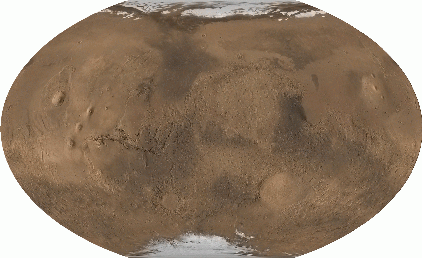
| Figure 2. A Winkel Tripel projection of Mars
|
Prior to 1998, the Winkel Tripel was a fairly obscure projection. However,
when the National Geographic Society announced that it was adopting the Winkel
Tripel as its standard world projection, it almost certainly ensured that the
projection will become much more popular in the near future. This increase in
popularity has been quite evident to those of us who work in the cartography
field, and its not hard to find examples of the Winkel Tripel in use: Figure 2
shows an example of the Winkel Tripel projection being used to map the surface
of Mars. Only the future will tell if the popularity of the Winkel Tripel will
continue to grow.